Property Record
1909 Unknown, , FL
Property Detail
1909 Unknown
Palm Bay-Melbourne-Titusville, FL
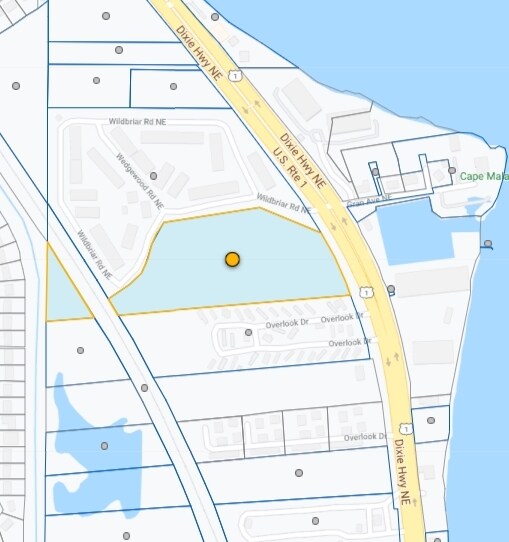
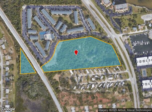
PART OF GOVT LOT 1 & PART OF SW 1/4 OF SW 1/4 AS DESC IN ORB 5100 PG 2481
28-38-30-00-00501.0-0000.00
Brevard
Multifamilyacreage
Florida
X
1
12009C0614H
9.30 AC
2024
Brevard County
2025
Orlando
065201
NEARBY LISTINGS FOR SALE OR LEASE
DEMOGRAPHICS near 1909 Unknown
1 mile
3 mile
5 mile
2024 Total Population
4,272
25,512
79,253
2029 Population
4,638
28,052
87,393
Pop Growth 2024-2029
+ 8.57%
+ 9.96%
+ 10.27%
Average Age
44
48
45
2024 Total Households
1,846
11,258
34,868
HH Growth 2024-2029
+ 8.40%
+ 9.88%
+ 10.14%
Median Household Inc
$54,903
$55,866
$49,662
Avg Household Size
2.20
2.20
2.20
2024 Avg HH Vehicles
2.00
2.00
2.00
Median Home Value
$168,840
$240,782
$238,742
Median Year Built
1973
1983
1985
Nearby Places
Map Layers
Map Styles
 Street
 Aerial
Transit
 Traffic
 Biking
Places
Listings with unknown addresses are not visible on the map
- Restaurants
- Banks
- Shops
- Fitness
- Groceries
PUBLIC TRANSPORTATION
AIRPORT
Melbourne Orlando International
Drive
Walk
Distance
Melbourne Orlando International
19 min
8.9 mi
Freight Ports
Port Canaveral
Drive
Walk
Distance
Port Canaveral
58 min
32.6 mi
SALE & LEASE HISTORY
LISTING DATE
SALE/LEASE

Oct 02, 2020
For Sale
Mar 10, 2021
For Sale
Nearby Properties
Address
Land Use
TOTAL SIZE
Lot Size
Zoning
Address
Land Use
TOTAL SIZE
Lot Size
Zoning
1,695,838 SF
106.06 AC
Address
Land Use
TOTAL SIZE
Lot Size
Zoning
408,025 SF
15.72 AC
Address
Land Use
TOTAL SIZE
Lot Size
Zoning
282,680 SF
16 AC
IU
Address
Land Use
TOTAL SIZE
Lot Size
Zoning
326,454 SF
14.20 AC
RM20
Address
Land Use
TOTAL SIZE
Lot Size
Zoning
393,147 SF
38.03 AC
RM20
Address
Land Use
TOTAL SIZE
Lot Size
Zoning
39.75 AC
GML
Address
Land Use
TOTAL SIZE
Lot Size
Zoning
560,257 SF
118.47 AC
LI
Address
Land Use
TOTAL SIZE
Lot Size
Zoning
2,366 SF
32.43 AC
SR
Address
Land Use
TOTAL SIZE
Lot Size
Zoning
4,000 SF
12.20 AC
IU
Address
Land Use
TOTAL SIZE
Lot Size
Zoning
1,380 SF
21.87 AC
IU
Address
Land Use
TOTAL SIZE
Lot Size
Zoning
762 SF
49.89 AC
GML
Address
Land Use
TOTAL SIZE
Lot Size
Zoning
408,025 SF
24.10 AC
LI
Address
Land Use
TOTAL SIZE
Lot Size
Zoning
242,454 SF
14.13 AC
LI
Address
Land Use
TOTAL SIZE
Lot Size
Zoning
352,735 SF
130.85 AC
Address
Land Use
TOTAL SIZE
Lot Size
Zoning
135,917 SF
2.92 AC
HC
Address
Land Use
TOTAL SIZE
Lot Size
Zoning
23,945 SF
142.13 AC
GML
Address
Land Use
TOTAL SIZE
Lot Size
Zoning
35.96 AC
GML
Address
Land Use
TOTAL SIZE
Lot Size
Zoning
222,925 SF
12.75 AC
PUD
Address
Land Use
TOTAL SIZE
Lot Size
Zoning
76,534 SF
4.33 AC
HC
Address
Land Use
TOTAL SIZE
Lot Size
Zoning
202,908 SF
34.94 AC
LI
Address
Land Use
TOTAL SIZE
Lot Size
Zoning
48,492 SF
17.45 AC
OI
Address
Land Use
TOTAL SIZE
Lot Size
Zoning
109,650 SF
10.32 AC
CG
Address
Land Use
TOTAL SIZE
Lot Size
Zoning
77,817 SF
17.84 AC
2RS
Address
Land Use
TOTAL SIZE
Lot Size
Zoning
97,728 SF
12.77 AC
IU
Address
Land Use
TOTAL SIZE
Lot Size
Zoning
119,582 SF
10.40 AC
Address
Land Use
TOTAL SIZE
Lot Size
Zoning
226,478 SF
14.97 AC
LI
Address
Land Use
TOTAL SIZE
Lot Size
Zoning
78,357 SF
8.47 AC
BU1
Address
Land Use
TOTAL SIZE
Lot Size
Zoning
31.07 AC
GML
Address
Land Use
TOTAL SIZE
Lot Size
Zoning
103,422 SF
6.01 AC
LI
Address
Land Use
TOTAL SIZE
Lot Size
Zoning
70,208 SF
4.30 AC
LI
The World's #1 Commercial Real Estate Marketplace
Connect with us
© 2026 CoStar Group
The information above has been obtained from sources believed reliable. While we do not doubt its accuracy we have not verified it and make no guarantee, warranty or representation about it. It is your responsibility to independently confirm its accuracy and completeness. Any projections, opinions, assumptions, or estimates used are for example only and do not represent the current or future performance of the property. The value of this transaction to you depends on tax and other factors which should be evaluated by your tax, financial, and legal advisors. You and your advisors should conduct a careful, independent investigation of the property to determine to your satisfaction the suitability of the property for your needs.